
How To Find Your Property On FEMA’s Flood Insurance Rate Maps

What are FEMA flood maps?
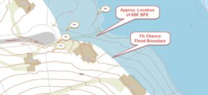
FEMA’s Flood Insurance Rate Maps (FIRMs) or just Flood Maps are provided after a flood risk assessment has been completed or updated for a community.  This study is known as a Flood Insurance Study.  The FIRM gives you the Base Flood Elevations (BFEs) and insurance risk zones in addition to floodplain boundaries.  The FIRM may also show a delineation of the regulatory floodway.

Once the “insurance risk zone”  (commonly referred to as the flood zone) is determined, actuarial rates, based on these risk zones, are then applied for newly constructed, substantially approved, and substantially damaged buildings.  FEMA uses these rates to determine the insurance rate you will pay for flood insurance

FEMA’s Digital Flood Maps

FEMA discontinued the production and distribution of paper flood maps in 2009 as part of its Digital Vision Initiative. This affected all the Flood Maps, boundary information, and study reports. However, clients can still view the products for free through their website or buy them in digital format.

To view these flood maps online, go to FEMA’s Map Service Center and key in your address (hi-lited area shown here) search for your home.  This will prompt you to then select the map that covers your area.  The Flood Maps are somewhat cumbersome to use online. It is best to go through the tutorial on the bottom right of the address search page for an easier and more effective use of the GIS map.

author avatar
Surveyor

More Posts

Rural Vermont farmland evaluated as part of a due diligence survey before purchase
alta survey
Surveyor

Due Diligence Survey Steps for Buying Rural Land

Rural land rarely comes with clear answers about where it starts and stops. Fences move over time. Stone walls often follow old cow paths, not deed lines. A tax map might show a neat square when the real boundary bends through the woods. If you are buying rural land under

Read More »
Aerial view of a commercial property and parking area for an ALTA title survey
alta survey
Surveyor

How an ALTA Title Survey Supports a Smooth Commercial Purchase

On many commercial deals, buyers order the ALTA title survey late, sometimes only a few weeks before closing. That timing puts stress on everyone. The survey does more when it starts early and stays part of the buying process from the first weeks under contract. Think of it as shared

Read More »
Surveyor performing a construction survey on a Vermont construction site
construction
Surveyor

What Does a Construction Survey Include?

A construction survey turns a project’s design into marks on the ground. What it includes shifts with the plans, the site, and what the surveyor was hired to do. This article covers what a construction survey can include, from prep to final records. What Information Is Prepared Before Construction Begins?

Read More »
A mortgage survey being completed for a Vermont home before the property closing
land surveying
Surveyor

When Does a Property Need a Mortgage Survey?

Not every property closing calls for a mortgage survey. Whether one is required comes down to the lender’s underwriting file, not a state law or a blanket rule. Here’s how the pieces fit together, and what to check before you order anything. Start With the Loan Instructions, Not a Blanket

Read More »
Boundary survey held beside a residential fence line, showing how a fence may differ from the surveyed property boundary
boundary surveying
Surveyor

The Fence Is Where? Reading a Boundary Survey

A boundary survey and a fence line are not always the same thing. On many older properties, the fence went up decades before anyone ordered a current survey. Reading the drawing correctly takes more than glancing at where the fence sits on the ground.  Start With the Survey’s Orientation, Not

Read More »
Surveyor using a total station to complete a construction survey on an active Vermont construction site
construction
Surveyor

When Do You Need a Construction Survey?

Plans get approved. Permits get signed. Then someone has to put a shovel in the ground in the right spot. A construction survey is what connects the paper design to the actual site, and knowing when a project needs one can save a contractor from tearing out work and starting

Read More »